Elko Corner Notch Projectile Point: Identification, Age & Range
Elko Corner Notch is a barbed, corner-notched Great Basin dart point of the Late Archaic, dated 3,500-1,400 B.P. and most often made of obsidian.
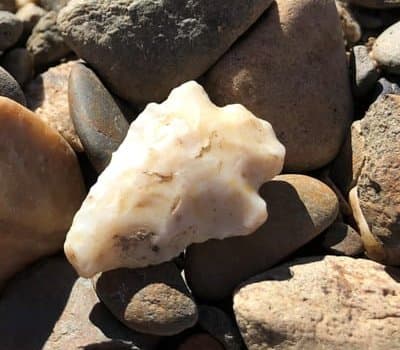
Photo: USDA Forest Service, Intermountain Region (cropped) · Wikimedia Commons (photo by USDA Forest Service, Intermountain Region — Uinta-Wasatch-Cache National Forest) · Public domain
At a glance
Period
3,500 - 1,400 B.P. · Late to Transitional Archaic
Typical size
24–88 mm long, 15–52 mm wide
Region
This point is found through-out the Great Basin, into the Snake River Plain and into southeastern Oregon into the Klamath Valley.
Ask a Nevada or Utah collector to name the most common dart point in their part of the world and the answer will often be Elko Corner Notch. This is the workhorse projectile of the later Great Basin Archaic: a sturdy, barbed, corner-notched point that tipped atlatl darts for roughly two thousand years. If you found a notched obsidian point in sagebrush country, Elko should be one of the first names you check.
Robert F. Heizer, working with Martin A. Baumhoff, defined the type in 1961 based on work at South Fork Shelter in Elko County, Nevada, the county that gave the point its name.
How to identify a Elko Corner Notch point
Elko Corner Notch points are dart-sized, not arrow-sized. Lengths run 24 to 88 mm, with most examples between about 33 and 51 mm, on blades 15 to 52 mm wide and 4 to 9 mm thick. That heft matters: the feather-light notched points of the same region belong to later arrow types.
The defining features sit at the base. Deep, narrow notches enter diagonally from each bottom corner, producing strong barbs that taper to sharp tips and reach out wider than the small ears at the base. The stem expands toward a straight or slightly concave base that stays clearly narrower than the blade measured across the barbs, typically by 10 to 20 mm. The triangular blade runs straight to slightly convex and frequently carries fine serrations along its edges. Flaking is usually random, though some pieces show a parallel oblique pattern.
Obsidian dominates as the material, followed by basalt and whatever workable stone was locally available, so a glassy black point with this outline is a strong Elko candidate.
Age and where it's found
The type dates to about 3,500 to 1,400 B.P., spanning the Late to Transitional Archaic. It belongs to a family that also includes Elko Eared, Elko Side Notch, and Elko Split Stem. These forms grade into one another: at some sites the eared form shows up earlier and peaks first, while at others, such as Gatecliff Shelter, the two occur together with no clear time difference.
The heartland is the Great Basin, with the range running up the Snake River Plain, into southeastern Oregon as far as the Klamath Valley, onto the northern Colorado Plateau, west to the Sacramento Valley, and south past the border into Baja California and Sonora, Mexico.
Think you found a Elko Corner Notch?
Upload a photo and our shape-matching AI will compare it against 1,000+ documented point types — with an honest read on how well it fits.
More type guides